SAEFARM : Satellite Crop ClassificationServices that apply this technology
Crop cultivation status, number of farms, and farm area
in just 15 minutes.Classify crops accurately for each plot based on high-resolution satellite information.

AI model processing for crop classification by pixelApply an automated AI model to high-resolution satellite images to analyze agricultural data for each pixel.
AI model processing for crop classification by pixelAggregate analyzed pixels to quickly and accurately grasp the cultivation status, number of farms, and farm area data for each crop.
Check out the satellite imagery-based
crop classification process using the SAEFARM AI model.
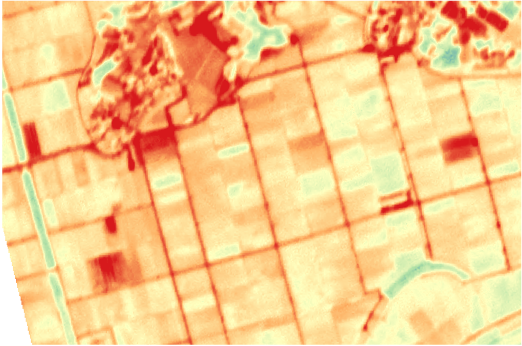
Data processing by pixelSAEFARM technology enables precise data processing at the pixel level. Each data point is processed by considering detailed information such as soil condition and weather environment.
SAEFARM AI Model for Field ClassificationThe SAEFARM AI model analyzes processed data to classify crops for each plot. The classified results are processed into crop-specific farm numbers, farm area, and cultivation environment.
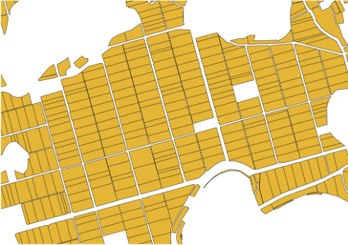
Map overlay visualizationWe provide intuitive agricultural maps with analyzed data. This agricultural map service helps administrators effectively grasp the overall situation of farmland and easily identify areas that need management.
Pursuing sustainable agriculture
amidst changing Earth and weather.SAEFARM closely observes changing weather conditions and cultivation environments. We are developing sustainable farming methods to proactively respond to future changes, continually evolving by combining the latest technology with field experience
SAEFARM Co., Ltd.
1301, 151 Gasan digital 1-ro, Geumcheon-gu, Seoul, Republic of Korea(Gasan-dong, Sejin InnoPlex)Representative | CEO Seunghwan Jeong
Business registration number | 655-87-02755
Phone number | 02-6959-0820
1301, 151 Gasan digital 1-ro, Geumcheon-gu, Seoul, Republic of Korea(Gasan-dong, Sejin InnoPlex)Representative | CEO Seunghwan Jeong
Business registration number | 655-87-02755
Phone number | 02-6959-0820

Introduction
Technology
Service
Contact